Introduction↑
Background
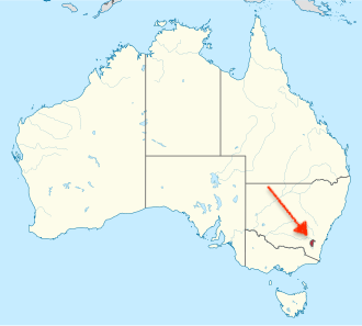
The Australian Capital Territory (ACT) is a compact inland territory completely surrounded by the state of New South Wales. Created specifically to house the nation's seat of government, the ACT is home to Canberra, the national capital of Australia. Designed as a planned garden city surrounding the artificial Lake Burley Griffin, Canberra serves as the political center containing federal parliament houses, national museums, and cultural monuments.
Geography↑
Land and Water
The geography of the ACT features rolling hills, grassy plains, and rugged high country, including part of the Brindabella Ranges along its western border. The Molonglo River flows through the center of Canberra and has been dammed to create Lake Burley Griffin, while Cotter River provides the territory's main water supply reservoirs.
Location: Southeastern inland Australia (enclosed by New South Wales)
Geographic coordinates: 35° S, 149° E
Area: total: 910 sq mi (2,358 sq km) | land: 893 sq mi | water: 17 sq mi
Bordering Regions: New South Wales
Elevation extremes: lowest point: Murrumbidgee River at ACT border ~1,476 ft (450 m) | highest point: Mount Bimberi 6,266 ft (1,911 m)
Population↑
Demographics
Population: 468,700 (2026 estimate)
Largest Urban Center: Canberra: 468,700 (Entire territory functions largely as the Canberra metropolitan area)
Age structure: 0-14 years: ~18.6% | 15-64 years: ~68.1% | 65 years and over: ~13.3% | Male: 49.5% | Female: 50.5%
Population growth rate: ~1.7% annually
Population density: 515 per sq mi (198.8 per sq km)
History↑
Indigenous Heritage and Federation Compromise
Traditional custodians of the Canberra region include the Ngunnawal, Ngambri, and Ngarigo peoples, who gathered in the local valleys for seasonal corroborees and bogong moth feasts for thousands of years. When the Australian colonies federated in 1901, a compromise was reached between rival cities Sydney and Melbourne to build a brand new capital city on neutral ground. The site was selected in 1908, the land was transferred from New South Wales to the Commonwealth in 1911, and an international design competition won by American architect Walter Burley Griffin shaped the modern layout.
Economy↑
Government, Education, and Technology
The economy of the Australian Capital Territory is driven primarily by public administration, defense, and federal government services. Alongside government employment, higher education institutions like the Australian National University (ANU), scientific research bodies, and high-tech professional industries support one of the highest average household income levels in Australia.
Fun Facts↑
Did You Know?
Designed from Scratch: Canberra wasn't built up by accident—it was planned out on paper before a single building went up, featuring a geometric design with sweeping circular avenues.
Bush Capital: Canberra is affectionately known as the "Bush Capital" because over half of its urban area is dedicated to green parks, nature reserves, and native pine forests where kangaroos roam freely!
Named After a Lake: Lake Burley Griffin right in the center of Canberra is named after Walter Burley Griffin, the American architect who designed the city layout.
Read more about the Australian Capital Territory on Wikipedia →